
Forest canopy structural complexity describes the three-dimensional (3D) arrangement of canopy elements, and it can influence forest ecosystem functioning together with species diversity by mediating within-canopy light and water distributions. Unraveling the relationship among canopy structural complexity, species diversity, and ecosystem functions is thus critical to understand forest ecosystem processes and make forest management and restoration plans. However, inconsistent correlations among them were reported across forest ecosystem types and even within the same forest ecosystem type. The lack of appropriate canopy structure complexity quantification methods was one of the major factors contributing to current inconsistent observations.
Light detection and ranging (lidar), especially the emerging near-surface lidar platforms (e.g., terrestrial laser scanning/TLS, backpack laser scanning/BLS, unmanned aerial vehicle laser scanning/ULS), can depict 3D canopy information with high efficiency and accuracy, providing an ideal data source for developing forest canopy structure complexity quantification methods. However, how to quantify forest canopy structure complexity with high effectiveness and generality from multiplatform lidar data is still a research bottleneck.
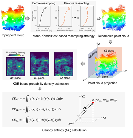
In order to address the bottleneck, a research team led by Prof. Yanjun Su from the Institute of Botany, the Chinese Academy of Sciences introduced the concept of entropy into forest canopy structure complexity quantification, and proposed a new forest canopy structural complexity index, namely canopy entropy (CE). Two major bottlenecks were addressed in the CE calculation procedure, including (1) using a Mann-Kendall test-based resampling strategy to address the issue of incongruent sampling chances of canopy elements at different locations from different lidar systems, and (2) using a projected kernel density estimation-based method to reduce its dependence on point density.
The effectiveness and generality of CE were evaluated by simulating TLS and ULS data from nine forest stands and collecting TLS, BLS, and ULS data from 110 field plots distributed in five forest sites, covering a large variety of forest types and forest canopy structural complexity conditions. The results showed that CE was an effective forest canopy structural complexity quantification index that captured canopy structural complexity variations caused by both tree density and the number of vertical canopy layers, and CE estimates from multiplatform lidar data agreed well with each other ( ≥ 0.70, RMSE ≤ 0.10), indicating it has generality in cross-platform forest canopy structural complexity quantification practices.
“The proposed CE index has great potential to help us unravel the correlations among forest CSC, species diversity, and forest ecosystem functions, and therefore improve our understanding on forest ecosystem processes,” said Prof. Su, corresponding author of the study.
The study was published in Remote Sensing of Environment recently, and was funded by the Frontier Science Key Programs of the Chinese Academy of Sciences and the National Natural Science Foundation of China.
Article Link: https://www.sciencedirect.com/science/article/pii/S0034425722003868?dgcid=coauthor
Contact:
SU Yanjun
Institute of Botany, Chinese Academy of Sciences
Email:ysu@ibcas.ac.cn
Forest canopy structural complexity describes the three-dimensional (3D) arrangement of canopy elements, and it can influence forest ecosystem functioning together with species diversity by mediating within-canopy light and water distributions. Unraveling the relationship among canopy structural complexity, species diversity, and ecosystem functions is thus critical to understand forest ecosystem processes and make forest management and restoration plans. However, inconsistent correlations among them were reported across forest ecosystem types and even within the same forest ecosystem type. The lack of appropriate canopy structure complexity quantification methods was one of the major factors contributing to current inconsistent observations.
Light detection and ranging (lidar), especially the emerging near-surface lidar platforms (e.g., terrestrial laser scanning/TLS, backpack laser scanning/BLS, unmanned aerial vehicle laser scanning/ULS), can depict 3D canopy information with high efficiency and accuracy, providing an ideal data source for developing forest canopy structure complexity quantification methods. However, how to quantify forest canopy structure complexity with high effectiveness and generality from multiplatform lidar data is still a research bottleneck.
In order to address the bottleneck, a research team led by Prof. Yanjun Su from the Institute of Botany, the Chinese Academy of Sciences introduced the concept of entropy into forest canopy structure complexity quantification, and proposed a new forest canopy structural complexity index, namely canopy entropy (CE). Two major bottlenecks were addressed in the CE calculation procedure, including (1) using a Mann-Kendall test-based resampling strategy to address the issue of incongruent sampling chances of canopy elements at different locations from different lidar systems, and (2) using a projected kernel density estimation-based method to reduce its dependence on point density.
The effectiveness and generality of CE were evaluated by simulating TLS and ULS data from nine forest stands and collecting TLS, BLS, and ULS data from 110 field plots distributed in five forest sites, covering a large variety of forest types and forest canopy structural complexity conditions. The results showed that CE was an effective forest canopy structural complexity quantification index that captured canopy structural complexity variations caused by both tree density and the number of vertical canopy layers, and CE estimates from multiplatform lidar data agreed well with each other (![]() ≥ 0.70, RMSE ≤ 0.10), indicating it has generality in cross-platform forest canopy structural complexity quantification practices.
≥ 0.70, RMSE ≤ 0.10), indicating it has generality in cross-platform forest canopy structural complexity quantification practices.
“The proposed CE index has great potential to help us unravel the correlations among forest CSC, species diversity, and forest ecosystem functions, and therefore improve our understanding on forest ecosystem processes,” said Prof. Su, corresponding author of the study.
The study was published in Remote Sensing of Environment recently, and was funded by the Frontier Science Key Programs of the Chinese Academy of Sciences and the National Natural Science Foundation of China.
Article Link: https://www.sciencedirect.com/science/article/pii/S0034425722003868?dgcid=coauthor
Contact:
SU Yanjun
Institute of Botany, Chinese Academy of Sciences
Email:ysu@ibcas.ac.cn